Your shopping cart is empty!
Shopping Cart
0 item(s) - $0.00
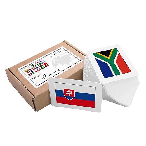
Carddia | Collection Of Country Flags Educational Flashcards | 242 Flags With Country Names, Maps, Capitals & Continents | Durable & Portable | Perfect For Geography Learning


Carddia | Collection Of Country Flags Educational Flashcards | 242 Flags With Country Names, Maps, Capitals & Continents | Durable & Portable | Perfect For Geography Learning
Price:
$73.10
Shipping & Taxes will be calculated at Checkout.US Delivery Time: 3-5 Business Days.
Outside US Delivery Time: 8-12 Business Days.

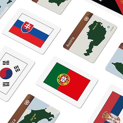
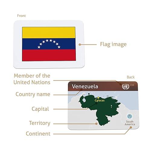
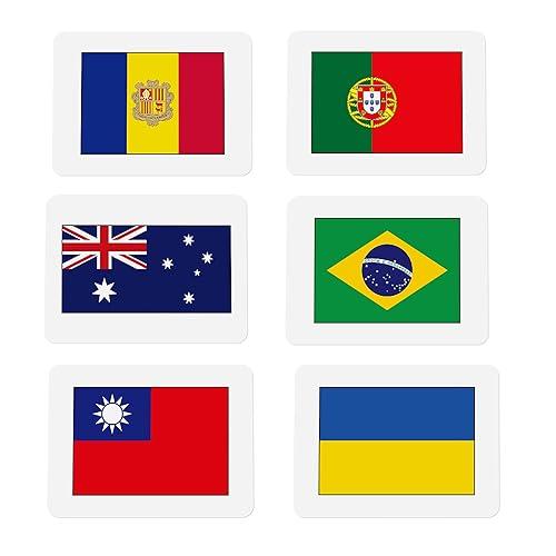
The Collection Of Country Flags Flashcard Deck Is A Premier Educational Tool Designed To Enrich Your Students' Or Kids' Learning Experience. Each Card Showcases A High-Resolution Image Of A Country'S Flag, Along With Its Name, Capital City, And The Continent It Resides On, Providing A Comprehensive Learning Tool. These Flashcards Are Invaluable For Geography Students, Assisting In Various Projects And Presentations, And Can Even Be Used As Educational Decor In Classrooms Or Labs, Making Them Versatile For Both Geography And History Lessons. These Cards Facilitate A More Engaging Learning Environment By Reducing The Reliance On Digital Technology And Videos, Promoting Interactive Discussions Between Teachers And Students. Educators Can Create An Immersive Learning Experience By Integrating These Flashcards Into A Larger World Map Display, Helping Students Visually Connect Each Flag To Its Respective Country. This Hands-On Approach Not Only Makes Learning More Intuitive But Also Sparks Curiosity And Enhances Memory Retention Of Geographical Details. 242 Flashcards: Includes All Un-Recognized Country Flags And Special Regions Like Hong Kong And American Samoa, Providing A Comprehensive Overview Of World Flags And Geography For Kids. Vibrant Front Design: Features High-Resolution Images Of Country And Region Flags In Vivid Colors, Making Them Visually Engaging And Perfect For Geography Games Or Study Activities. Informative Back Side: Provides Details Such As The Country Name, Map, Continent, And Capital City, Offering An Interactive Way To Learn About Flags Of The World And Global Geography. Durable And Portable: Made With Water- And Tear-Resistant Material, These Sturdy Country Flag Flash Cards Are Easy To Carry, Making Them Ideal For Travel Or Classroom Geography Gifts. Fun And Educational: Ideal For Students, Teachers, Travelers, And Flag Enthusiasts; Perfect For Geography For Kids, Classroom Activities, World Flags Projects, Or Family Learning Time.
Features
Specification
| Product Detail | |
|---|---|
| Color | Multi-Color |
| Size | Standard Poker Size (89 X 63.5 Mm) |
| Dimensions | 0.0393700787x0.882x3.5039370043 |
| Weight | 0.882 |
 Warning - California Proposition 65
 This product may contain chemicals known to the State of California to cause cancer, birth defects, or other reproductive harm.
Reviews (0)
Product FAQs
Q: What material are the flashcards made of?
Ans: The flashcards are made from high-quality cardstock, which is comparable to standard playing cards, ensuring durability and longevity.
Q: How many flags are included in the collection?
Ans: The collection includes a total of 242 flashcards, featuring all UN-recognized country flags as well as special regions like Hong Kong and American Samoa.
Q: Are these flashcards suitable for classroom use?
Ans: Yes, these flashcards are perfect for classroom activities, geography lessons, and can also serve as educational decor, promoting interactive discussions among students.
Q: How can these flashcards enhance learning?
Ans: These flashcards facilitate a hands-on learning experience, helping students visually connect flags to their respective countries, which enhances memory retention and sparks curiosity about global geography.
Q: Are the flashcards portable?
Ans: Yes, the flashcards are designed to be durable and portable, made from water- and tear-resistant material, making them easy to carry for travel, study sessions, or classroom use.
Q: Can these flashcards be used for geography games?
Ans: Absolutely! The vibrant front design and informative back side make these flashcards ideal for geography games and educational activities, making learning fun and interactive.
Q: What educational benefits do these flashcards provide?
Ans: The flashcards provide a comprehensive overview of world flags and geography, making them invaluable for students, teachers, and flag enthusiasts. They serve as an engaging tool for various projects and presentations.
Q: Are there any special features of the flashcards?
Ans: Yes, the flashcards feature a vibrant front design with high-resolution images and an informative back side that includes the country name, map, continent, and capital city, offering an interactive learning experience.
Tags: