


You will not be allowed to compare more than 4 products at a time
View compareBEST LEARNING i-Poster Interactive Map - Educational Talking Toy for Ages 5-12, Plastic, Original Version, Model 4226
BEST LEARNING i-Poster Interactive Map - Educational Talking Toy for Ages 5-12, Plastic, Original Version, Model 4226
Regular price
$77.37 USD
Sale price
$77.37 USD
Regular price
$110.53 USD
Unit price
per
Shipping calculated at checkout.
Hurry! Only left 5 in stock
Sold by ToyTooth — Your trusted kids' toy store.
Returns accepted within 30 days | support@toytooth.com
Shipping Information
- Shipping calculated at checkout
- Processing Time: 3–5 business days
- Estimated Delivery: 6–10 business days after dispatch
- Securely packed to ensure your purchase arrives in perfect condition
- Tracking number sent via email once dispatched
Returns & Refund
Returns accepted within 30 days of delivery.
Damaged or Defective Item
Free return shipping + replacement or full refund
Wrong Item Received
Free return shipping + replacement or full refund
Change of Mind
Return shipping at customer's expense · Item must be unused & in original packaging
All returns require a Return Authorization (RA) number before sending.
View Full Return & Refund Policy
Safety & Compliance
⚠️
California Proposition 65 Warning
Some products sold on this website may expose you to chemicals known to the State of California to cause cancer, birth defects, or other reproductive harm.
www.P65Warnings.ca.gov
🛒
General Product Safety Advisory
Always read the product label, instructions, and safety warnings before use. Do not use damaged or modified products. Store products in appropriate conditions as specified by the manufacturer.
Keep all products out of reach of children unless specifically designed for their use.
ℹ️
Product Authenticity & Notice
All products sold by ToyTooth are 100% authentic, sourced directly from trusted toy suppliers and brands. Product colors and dimensions may vary slightly from images due to screen calibration and manufacturing tolerances.
ToyTooth — Fun Toys for Every Kid, Delivered to Your Door.
Share
Couldn't load pickup availability
Guarantee safe and secure checkout
Description
Description
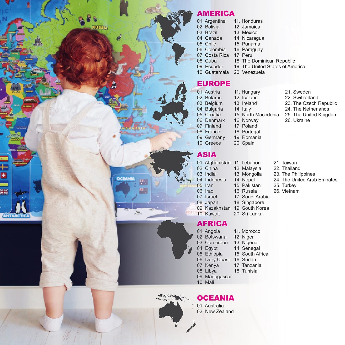
Discover the BEST LEARNING Original Version Interactive Smart Educational Talking World Map Poster, an award-winning fun learning toy designed for children aged five and up. This educational poster provides an engaging way for kids to explore world geography, countries, and cultures while developing essential skills through interactive play.
Crafted from high-quality plastic, this map poster features a vibrant design that captivates young learners. It includes a fabric frame for easy wall hanging or as a colorful play mat on the floor. The poster is not only visually appealing but also functional, offering over 1000 facts and questions about the globe. Designed for preschoolers and early learners, it effectively combines education and entertainment, making learning about the world enjoyable.
Key Features:- Award-Winning Design: Recognized with several prestigious awards including Family Choice and Mom's Choice Gold Metal.
- Interactive Learning: Engages children with capital cities, countries, flags, population, and languages spoken.
- Fun Facts: Provides over 1000 fun facts and questions, enhancing children's knowledge of the globe.
- Skill Development: Aids in the development of concentration, memory, problem-solving, and geography skills.
- Versatile Use: Can be hung on a wall or used as a colorful play mat for versatile learning experiences.
- Safe and Ready to Use: Operates with 3 AAA batteries, which are included for immediate fun.
- English Language: All content is provided in English, catering to early learners seeking foundational geography knowledge.
This interactive world map poster is ideal for parents, educators, and caregivers looking to enrich children's learning experiences. It combines fun and education, making it a perfect gift for birthdays, holidays, or as a classroom resource. The BEST LEARNING Original Version ensures that children not only learn about geography but also build critical thinking and problem-solving skills through engaging play. Invest in your child's educational journey today with this innovative learning tool.


Frequently Asked Questions
- Q: What are the dimensions of the BEST LEARNING i-Poster My World Interactive Map? A: The dimensions are thirty-six point zero two inches in length, twenty-six point nine seven inches in height, and zero point nine eight inches in width.
- Q: What material is the interactive map made from? A: The interactive map is made from plastic, ensuring durability and ease of use for children.
- Q: How many facts and questions does the map offer? A: The map offers over one thousand facts and questions about the globe, enhancing the learning experience.
- Q: How do children use the interactive map? A: Children can explore and learn about capital cities, countries, flags, and fun facts by touching various areas of the map.
- Q: What age group is the interactive map suitable for? A: The map is ideal for children aged five to twelve years old, making it perfect for preschoolers and early learners.
- Q: Are batteries included with the interactive map? A: Yes, three AAA batteries are included, allowing for immediate use right out of the box.
- Q: How should I care for the interactive map? A: To care for the map, keep it in a dry place and avoid exposure to moisture to maintain its quality.
- Q: Is the map safe for young children? A: Yes, the map is designed as a safe educational toy for children aged five and up, with no hazardous materials.
- Q: Can the interactive map be hung on a wall? A: Yes, the map features a fabric frame that allows it to be easily hung on a wall or used as a colorful play mat.
- Q: What awards has the interactive map received? A: The map has won multiple awards, including Family Choice, Mom's Choice Gold Medal, and Tillywig Brain Child Award.
- Q: Is the map only available in English? A: Yes, the interactive map is only available in English, providing facts and information in that language.
- Q: What skills can children develop by using the map? A: Children can develop skills in concentration, memory, problem-solving, geography, and environmental awareness through interactive play.
- Q: Are there any regions on the map that are unavailable for exploration? A: Yes, white areas on the map represent regions currently unavailable for exploration, while vibrant yellow areas are ready for learning.
- Q: What types of learning does the interactive map promote? A: The map promotes fun learning through exploration of geography, cultures, and important global facts.
- Q: Is there a warranty for the interactive map? A: Yes, the manufacturer typically offers a warranty for defects, so check the packaging for specific details.
- Q: What if the interactive map arrives damaged? A: If the map arrives damaged, you should contact the retailer for return or exchange options to resolve the issue.